stage
anomalies
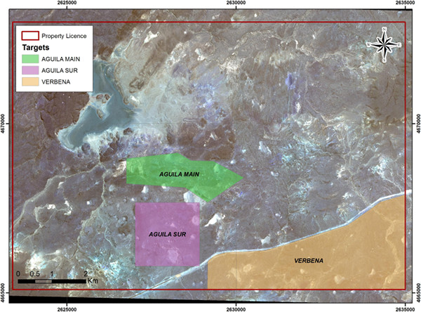
The project is located in the Oriental part of the Deseado Massif and comprises three licence blocks that include covering some 9,124 ha in total. El Aguila project is located 70 km northeast of Cerro Vanguardia mine and 45 km southwest of Cerro Moro.
El Aguila has different sectors identified by the type of mineralization representing epithermal deposits: veined, stockworks and breccias and a new exploration target represented by veins in sandstone associated to dome.
The geological interpretation defined Aguila to represent a caldera environment. The structure is represented by ring fractures at the margins of the caldera striking: EW; NS; NNW and NW. The NW orientation is strike-slip faults with dextral movements, and tensional are NS fractures, post-mineral ENE system displace part of the vein-like mineralized structures.

Based on geological features five main sectors have been defined: Aguila Main - Verbena - Aguila Sur - San Cristobal, standing out as the most important by the potential Aguila Main and Verbena. In this property the best results of Au and Ag were obtained in surface samples and trenches.
| El Aguila - Best Intersections | |||||||||
|---|---|---|---|---|---|---|---|---|---|
| Surface sample | SECTOR | Au g/t | Ag g/t | As [ppm] | Cu [ppm] | Mo [ppm] | Pb [ppm] | Sb [ppm] | Zn [ppm] |
| 5 | Aguila Main | 3.32 | 450.32 | 129.16 | 70.92 | 22.95 | 1293.2 | 29.07 | 89.82 |
| 105 | Aguila Main | 3.22 | 326.78 | 105.47 | 65.73 | 45.13 | 1018.56 | 44.01 | 24.53 |
| 107 | Aguila Main | 77.36 | 455.4 | 195.45 | 28.6 | 04.07 | 124.18 | 73.67 | 2.4 |
| 110 | Aguila Main | 44.21 | 4738.79 | 448.21 | 114.89 | 18.65 | 10000 | 90.44 | 63.99 |
| 494 | Aguila Main | 7.93 | 37.57 | 127.78 | 39.93 | 10.02 | 39.42 | <5 | 32.44 |
| 503 | Aguila Main | 7 | 11.35 | 177.67 | 27.1 | 24.05 | 68.91 | <5 | 41.44 |
| 506 | Aguila Main | 5.18 | 90.7 | 224.03 | 75.93 | 34.09 | 14.67 | <5 | 60.49 |
| 572 | Aguila Main | 12.73 | 2300.91 | 617.54 | 176.79 | 41.25 | 4664.81 | 60.4 | 44.87 |
| 574 | Aguila Main | 1.75 | 343.74 | 138.88 | 52.56 | 5.67 | 1379.89 | <5 | 16.27 |
| 575 | Aguila Main | 9.16 | 1420.59 | 149.45 | 13.85 | 6.36 | 85.67 | <5 | 14.75 |
| 576 | Aguila Main | 0.57 | 65.47 | 38.41 | 10.32 | 4.75 | 112.7 | <5 | 6.76 |
| 578 | Aguila Main | 5.52 | 9.3 | 417.95 | 13.74 | 10.89 | 251.7 | 27.91 | 17.88 |
| 2 | Aguila Sur | 13.81 | 03.09 | 459.93 | 6.46 | 5.14 | 12.07 | 26.97 | 9.99 |
| 70 | Aguila Sur | 02.09 | 5.15 | 1052.95 | 5.16 | 5.91 | 39.92 | <5 | 7.9 |
| 549 | Verbena | 0.08 | 30.9 | 76.89 | 11.46 | 2.43 | 25.28 | <5 | 134.22 |
| 630 | Verbena | 01.02 | 2.72 | 655.74 | 8.21 | 3.61 | 9.13 | <5 | 2.89 |
| 666 | Verbena | 0.81 | 70.53 | 291.19 | 13.73 | 26.26 | 16.09 | <5 | 9.17 |
Aguila Main
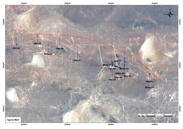
The mineralization is characterized by stockworks and in some cases develops breccia textures, minor hydrothermal breccias, host rock replacements and quartz veins. These veins show two orientations, one N70°E parallel to the dyke’s strike outcropping in the most eastern part of the rhyolite dyke with maximum thickness of 0.80 meters, and the second one with N25°E strike averaging 0.30 meters in width.
Based on evaluation of drilling, a mineralized area of 1,200 m in length was identified; the dyke outcrops approximately 2300 m along the strike, with the mineralized belt open in both direction and in depth.

Previous drillholes have had anomalous values, like DDA-42 with an intersection of 0.86 m @ 19.57 g / t Au and 41.04 g / t Ag between 299.38 m 300.24 m along the length of the hole, in the contact between the dyke and the andesite (approximately 240 m of vertical depth).
Verbena
Minera Fredonia’s first survey of the area, to verify some of the data contained in Minera Mariana Argentina S.A. report, has concluded the potentiality marked by strong alterations resulting from hydrothermal solutions, and ample sectors with abundant floats of quartz vein.
The Verbena area have a length of 2 km in an East-West direction by 2.5 km in a North-South direction; within it a sector is distinguished in the central and western part, with outcrops of breccias, sandstones, abundant floats, well-defined veins and in general alterations representative of the upper part of an epithermal system and the development of replacement’s vein structures in sandstones of the La Golondrina Formation, related to the vicinity of a rhyolitic dome of more than 0.25 km² to the south limit of the property.
In the vicinity of the provincial road several quartz veins are hosted in ignimbrites, obtaining in a sample a value of 2.45 g / t Au. It is considered this very prospective with quartz veins with up to 2 m of thickness, proposing a drillhole to cut this structure at depth. It is notable the correlation between surface sample data which shows an As-Mo-Mn geochemical association representative of the upper part of the system and a correlation between Pb and Ag as well. At the eastern sector replacement veins were mapped hosted in sandstones, where gold values were recorded (MFEA-08 drillhole).
This target remained unexplored until the geological survey and exploration work carried out by Minera Fredonia.
The vein system is characterized by the strong presence of disseminated Fe oxides, with very persistent contents of Au <1 g / t, and there is an intimate relationship between these structures in contact with a rhyolitic dome, through which mineralizing solutions have risen.
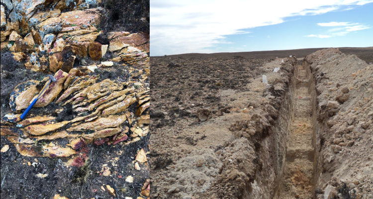
In addition to surface sampling, anomalous values were found in the trench VB04 and the drillhole MFEA-08. The last mentioned intersected three sections with gold mineralisation (8 m @ 0.19 g/t Au; 3 m @ 0.64 g/t Ag and 18 m @ 0.21 g/t Au).
As the most important result of this first exploration stage, Verbena emerged as two sectors with very good potential, about which only limited data from surface samples were known.
The analysis and evaluation of the data obtained determined the convenience of continuing exploration work, especially in the western sector of Aguila Main and Verbena.
